
Item number: EUR3164BGenuine Antique Map
1940
Maker: Rand-McNally
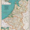
Antique printed color map of British Isles, published in 1940 by Rand-Mcnally as part of the Colliers World Atlas and Gazeteer. Includes Ireland, Shetland Islands, and the English Channel. Good condition, approximately 14″ x 11″ to the paper edges.
Item Number: EUR3164B
Related products
-52%

Labels, Indexes & Stamps
Original price was: $10.50.$5.00Current price is: $5.00.
-63%

Office & School Supplies
Original price was: $2.73.$1.00Current price is: $1.00.
-70%

Office & School Supplies
PLATINUM Limited Edition #3776 Century Fountain Pen – Rokka Low Cost Sale Online
Original price was: $320.00.$97.00Current price is: $97.00.
-48%

Desk Accessories & Workspace Org
Original price was: $24.90.$13.00Current price is: $13.00.