
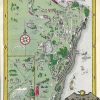
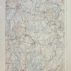
Item number: TOP377Genuine Antique Map
1928
Maker: U.S. Geological Survey
Antique colorized topographical map of Port Henry, includes Vergennes, Ferrisburg, and Westport. Good condition, toned, approximately 20″ x 15″ to the paper edges.
Item Number: TOP377
Related products
-63%

Office & School Supplies
Original price was: $2.73.$1.00Current price is: $1.00.
-52%

Envelopes, Mailers & Shipping Su
Kuromi Cherry Die-Cut Letter Set Free Shipping Release Dates
Original price was: $6.23.$3.00Current price is: $3.00.
-52%

Labels, Indexes & Stamps
Original price was: $10.50.$5.00Current price is: $5.00.
-67%

Office & School Supplies
Original price was: $2.99.$1.00Current price is: $1.00.