

Item number: NYO194Genuine Antique Hand-Colored Map
1911
Maker: Everts Publishing Co.
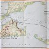
Antique hand-colored map of Westchester County, New York from the New Century Atlas of the Empire State, published by Everts Publishing Co., 1911. Includes:
Fair to good overall antique condition, with some damage and toning at the paper edges and creasing at center fold. Some slight stains. Measures approx. 29.5 x 22.25 inches. Price reduced for condition.
Item Number: NYO194
Related products
-50%

Office & School Supplies
Original price was: $14.00.$7.00Current price is: $7.00.
-67%

Office & School Supplies
Original price was: $2.99.$1.00Current price is: $1.00.
-48%

Desk Accessories & Workspace Org
Original price was: $3.85.$2.00Current price is: $2.00.
-48%

Desk Accessories & Workspace Org
Kuromi Cheeky But Charming Rotating Pen Stand Buy Cheap Fake
Original price was: $22.90.$12.00Current price is: $12.00.