
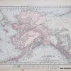

Item number: TOP41 Genuine Antique Topographic map
1898
Maker: USGS.
Antique topographic map of Lake Champlain showing the Chesterfield, Willsboro, Essex area in New York and edge of Charlotte and Shelburne in Vermont, Prospect Hill and Rattlesnake Mountain in NY, Crolea, Willsboro, Whallon, and McNeal Bays, railroad lines and the New York – Vermont state border. Very good condition. Sheet size is 20″h x 16″w.
Item Number: TOP41
Related products
-52%

Envelopes, Mailers & Shipping Su
Kuromi Cherry Die-Cut Letter Set Free Shipping Release Dates
Original price was: $6.23.$3.00Current price is: $3.00.
-66%
Education & Crafts
Original price was: $155.00.$52.00Current price is: $52.00.
-52%

Labels, Indexes & Stamps
Original price was: $10.50.$5.00Current price is: $5.00.
-63%

Office & School Supplies
Original price was: $2.73.$1.00Current price is: $1.00.