

Item number: VER084 Genuine Antique Hand Colored Map
1869
Maker: Beers.
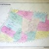
Antique hand colored map of the town of Wardsboro, with inset maps of partial Wardsboro and Unionville, from the Atlas of Windham, Vermont, published by Beers, 1869. Map is colored by district and includes a business directory, topographical detail, and the names of property owners at the time of publication. Good to overall antique condition with toning throughout, areas of foxing/staining, and some edge wear. Measures approximately 14″ x 11″ (H x W) to the edge of the decorative border.
Item Number: VER084
Related products

Office & School Supplies

Office & School Supplies
Kuromi Cheeky But Charming Die-Cut Memo Pad From China For Sale

Office & School Supplies

Office & School Supplies