
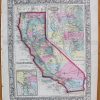
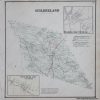
Item number: NYO707 Genuine Antique Hand Colored Map
1866
Maker: Stone & Stewart.
Antique hand colored map of the town of Hartford, New York. Shows land owners in the area at the time of publication. Published in the “New Topographical Atlas of Washington County, New York,” by Stone and Stewart, 1866. Very good overall antique condition with mild toning throughout and some areas of very minor foxing. Measures approximately 12.75″ x 11.5″ to the neatline.
Item Number: NYO707
Related products
-67%

Office & School Supplies
Original price was: $2.99.$1.00Current price is: $1.00.
-47%

Office & School Supplies
Original price was: $1.90.$1.00Current price is: $1.00.
-46%

Desk Accessories & Workspace Org
Original price was: $12.90.$7.00Current price is: $7.00.
-52%

Labels, Indexes & Stamps
Original price was: $10.50.$5.00Current price is: $5.00.