
Item number: MAT122Printed Color Genuine Antique Map
1907
Maker: Scarborough Publishing Company.
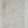
Printed color antique folding map of Pennsylvania made by the Scarborough Company in 1907. Showing all counties, townships, cities, boroughs, villages, post-offices, and Railway Stations with distances between stations in statute miles and decimal fractions of miles. Compiled from the latest government and state surveys and original sources. Showing Steam Railways and suburban Electric Lines and the principal Highway Connections across the mountains. Upper right corner has a table showing the distances saved by the Panama Canal along with three maps of Panama and the canal, as well as a map of the city of Philadelphia. Fair Antique condition with light minor surface soiling and some seam separation. Approx. 38 x 52 inches when open. Folded size is approx. 10 x 5 inches.
Item Number: MAT122
Related products

Desk Accessories & Workspace Org

Office & School Supplies
Kuromi Cheeky But Charming Die-Cut Memo Pad From China For Sale

Forms, Recordkeeping & Money Han
Kuromi Cheeky But Charming Coin Bank With Lock Cheap Sale Countdown Package

Education & Crafts