
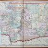
Item number: WOR214 Genuine Antique Printed Color Coast
1900
Maker: Coast and Geodetic Survey.
Antique printed color Coast and Geodetic Survey Map showing the changes in tidal levels around the world during the Spring of 1900, with a color chart for reference. Published by the Coast and Geodetic Survey Report, 1900. Very good condition with very mild toning of the antique paper. Measures approximately 8″ x 13.5″ to the neatline.
Item Number: WOR214
Related products
-46%

Desk Accessories & Workspace Org
Original price was: $12.90.$7.00Current price is: $7.00.
-47%
Office & School Supplies
Original price was: $1.90.$1.00Current price is: $1.00.
-52%

Labels, Indexes & Stamps
Original price was: $10.50.$5.00Current price is: $5.00.
-48%

Desk Accessories & Workspace Org
Original price was: $3.85.$2.00Current price is: $2.00.